Showing posts with label road biking. Show all posts

Thursday, February 16, 2017

A cool cycling trip to Tagaytay


My bike, Red, with Taal Lake and Taal Volcano on the background.
By now, you’ve probably noticed already the sudden drop in temperatures these past weeks. Some parts of Benguet Province are a freezing -2° Celsius, while in Metro Manila, it’s been fluctuating between 21° and 24° Celsius. It’s winter in many parts of the northern hemisphere and cold winds coming from Siberia, China and Japan are being blown into the country. Waking up these days are defined by sweater weather and cold feet. Taking a bath necessitates having hot water mixed with the tap water in your pail.

This is also a great opportunity to bike, given that it’s not too hot in the day and the chilly amihan provides a lot of ventilation.

And one of the many destinations that bikers in the Philippines love to go to in this kind of weather is Tagaytay City in Cavite, the Second Summer Capital of the Philippines after Baguio City in Benguet.

Last October, I attempted my first-ever bike ride from Bacoor to Cavite’s City of Pines. It’s a 35-kilometer distance from my home through uphill roads and foggy terrain (depending on the weather). 
Normally, bikers take the usual route via the Aguinaldo Highway, the main artery that passes through Cavite from Bacoor to Tagaytay City. However, the highway also has a reputation for being accident prone for both bicycles and motorists. Being that my safety is of my foremost concern, I decided not to go up to Tagaytay through the highway.

Instead, I took the safer route via the country roads of Silang to reach the city. From Bacoor, it’s just a straight line to Governor’s Drive in Paliparan, Dasmariñas City, where the Molino-Paliparan Road connects to Paliparan-Road that would lead me to the backdoor of Silang town.

I realized I never really talked about biking along Molino-Paliparan Road. This 23-kilometer road runs from Talaba Junction in Bacoor and goes all the way south to Paliparan, Dasmariñas City. Among the major roads in Bacoor that connect through it are Aguinaldo Highway, Bacoor Boulevard and Daang Hari. It also intersects with Salitran Road and Governor’s Drive in Dasmariñas City. It is probably one of the oldest roads in Bacoor since it passes through some of the older barangays of Bacoor like Aniban, Ligas and San Nicolas. As such, throughout much of its stretch through these barangays, the road is a two-lane asphalt that widens once you reach the barangays of Molino. Bikers must share the road with motorists in this section so tread carefully.

From Molino I to Paliparan, it transforms into a four-lane cemented road because much of the road widening can only be done in the newer barangays of Bacoor and Dasmariñas City. However, because of the widening, motorists tend to hog even the outer lanes, especially at intersections along Bacoor Boulevard and Daang Hari where traffic is common. After passing SM City Molino, it’s generally smooth sailing until you reach Paliparan.

After a rest at a 7-11 along Governor’s Drive in Paliparan, I made my way to the Paliparan-Silang Road, which is just a few meters to the right. Your landmark would be the Paliparan Barangay Hall. Paliparan-Silang Road is a two-lane concrete road that runs through subdivisions and sugarcane plantations in Dasmariñas and Silang. You would know you’re already in Silang because you’ll pass by a marker with a large clay pot on top. The Silang section of the road begins to have an incline because of the increasing elevation. You’ll also notice that flower and pineapple plantations, as well as flower and plant gardens begin to line the side of the road.

Before noon, I reached Silang Proper. I didn’t pass through downtown Silang though and instead pedaled through the back streets of the town. I had lunch of rice and dinuguan in one of the carinderias along Sabutan-Iba Road. After that, I made my way to Ulat Road, which is an old, two-lane road that leads all the way up to the Santa Rosa-Tagaytay Road. The uphill terrain is more pronounced here than in the previous roads. There were sections that I had to literally get off the bike and push forward. To make things worse, it began to rain and despite wearing a raincoat, I was drenched in sweat and moisture underneath. I was forced to stop and take shelter at a store in Brgy. Balite.

Posing with my bike to beautiful backdrop of Taal Lake behind.
Finally, after about an hour, the rain stopped, and I proceeded despite being wet, shivering and pedaling uphill. At around 2:30 p.m., I reached Santa Rosa-Tagaytay Road just near Tagaytay Haven Hotel, but still a few kilometers from a decent view of Taal Lake.

After an hour’s rest at a sari-sari store near Tagaytay Haven Hotel, I continued my journey southwest along Santa Rosa-Tagaytay Road. There’s plenty of traffic once you’re near the Tagaytay City Public Market because of an ongoing road construction. Plus, it was a Sunday, so there’s a bigger volume of vehicles on the road. Do take care while biking along this road because there are plenty of trucks and buses that ply this two-lane asphalt road that has no provision for sidewalks. Use hand signals to indicate turns or stops.

Around 3:30 p.m., I finally reached the Tagaytay-Calamba Road in front of the Tagaytay Econo Hotel. From there, one can already get a spectacular view of Taal Lake and Taal Volcano. I was shivering in the 24° Celsius weather, but I still made a few obligatory shots to record my achievement.

Having made it to Tagaytay, the next predicament was going home. Since it was already past the middle of the afternoon, I figured I’m going to be on the road until nightfall. It’s going to be a scary, dangerous gamble if I pedaled the way I came or if I go back via Aguinaldo Highway with only a lamp as my light. I decided not to take the risk and headed to Tagaytay Rotunda where I took Red and myself aboard a Baclaran-bound bus and went down at Patindig Araw, Imus, where I pedaled the rest of the way going home.

My total bike distance and time via MapMyRide.
All in all, my bike ride from Bacoor to Tagaytay was 35.49 kilometers long, which I completed in just four hours and five minutes. Not bad for an inaugural bike ride to the country’s Second Summer Capital. But for all the toils and sweat I poured for this tour, it was one of the coolest bike rides I’ve ever been to. I’ll definitely go back to Tagaytay this year and see if I can bike to and from it.

Like The Pinoy Cyclist on Facebook:

Sunday, January 1, 2017

2016: A year of cycles and pedals


Another turn of the year has passed. This is usually the time to look back at some of the major events that happened in the past 365 days. Hence, the multitude of year-end TV specials that air around this time. Being a well-traveled person, my journeys have allowed me to experience cycling in some of the most beautiful places to bike in the country. Here are my top cycling experiences of 2016:

February: Biking in Legazpi
Recently, I’ve taken up the practice of traveling alone to some far-off destination in the country. This started in 2015 when I backpacked through Negros Island and Siquijor. Having saved enough money this year, I set my sights on visiting Legazpi City in Albay to see Mayon Volcano. And just like what I did in Siquijor, I also took the opportunity to experience biking in this new destination.

Luckily, Legazpi City has some of the best bike infrastructures I’ve seen in the country, with bike lanes along Legazpi Boulevard and other major streets. There is also a bike shop, Motoragon Bike Shop and Bike Tours, that offers affordable bike rentals. When I visited the shop, it so happened that my celebrity idol, Rovilson Fernandez, was also taking a bike tour with the shop owner for his Malaysian travel show. The shop let me borrow a folding bike, which I used to go around the city looking for fancy restaurants and cool sights and activities. It was exhilarating biking around the city at night. By 9 p.m., the streets were literally deserted with very few vehicles on the road. If only it didn’t rain that hard on my second day there, I would’ve enjoyed the experience even more.

May: Giro di Luca in Bohol
When I first heard from my company that they’re sending me to Bohol for the annual Giro di Luca cycling event, I thought I died and went to bike heaven. After all, it’s quite out of this world for your company to send you and your bike to one of the most beautiful places in the Philippines just to bike!

Giro di Luca is an annual cycling event in Bohol that’s been going on for the last four years. It was established by veteran cyclist Gianluca Guidicelli, father of Kapamilya star and Ford Forza Triathlon member Matteo Guidicelli. My company sent me and my bike to the event as part of Ford’s promotional activities. They wanted me to experience the race for myself and see how reliable Ford’s fleet of vehicles were during the race. The three-day event covers as total of 500 kilometers in distance, which the cyclists must complete in three legs: Panglao to Guindulman in Day 1, Panglao to Carmen in Day 2 and Panglao to Tubigon on Day 3.

To make the story short, Red, my humble, ₱4,000-worth bicycle, was able to ride an airplane (in an embarrassing wraparound of box cartons) and ride with some of the biggest names in cycling in the country and abroad (including SportsU anchor Dyan Castillejo and Australian cycling power couple Belinda and Justin Granger)! And while I didn’t finish the race because of the physical toll of the distance, I saw how idyllic and picturesque it is to go around Bohol in a bicycle. It was a whole new way of experiencing Bohol.

September: Pedaling to General Trias
I’ve always wanted to visit Cavite’s other towns and cities on a bike. In 2015, Red and I reached Cavite City, Noveleta, Kawit, Rosario, Tanza, Ternate, Maragondon, GMA, and Carmona, while I’ve always biked through the cities of Bacoor, Imus and Dasmariñas since I was in my teens. That leaves the other upland towns and cities of Cavite for me to visit.

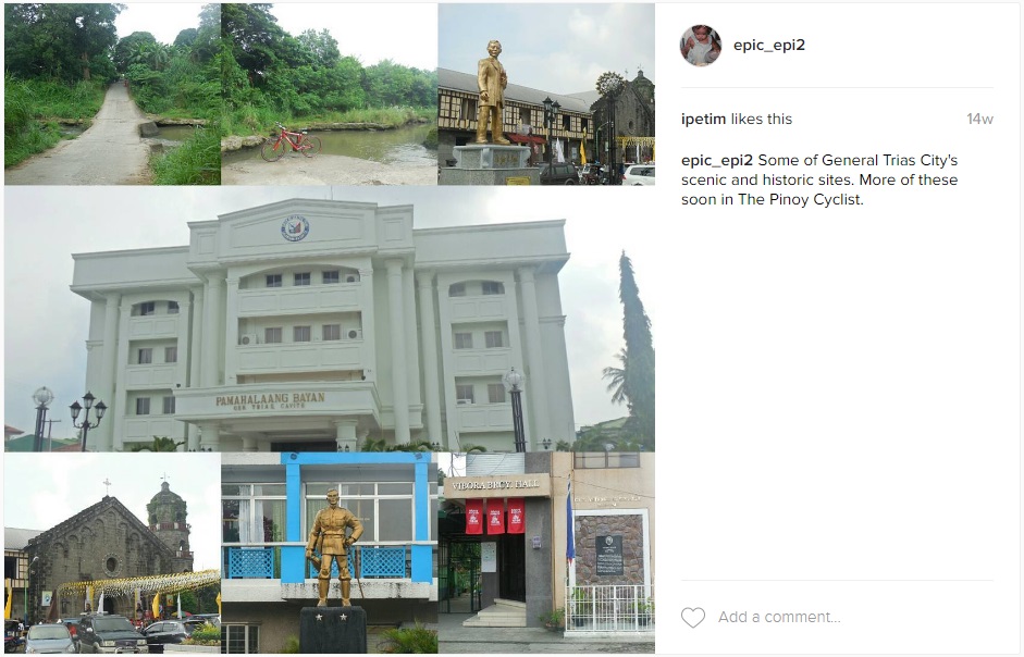
Through the wonders of Google Street View, I found a shortcut from my house to General Trias, Cavite’s newest city. In under two hours, I reached the historic city by passing through Patindig Araw in Imus City and Advincula Avenue in Lancaster New City. Among the places I visited were the St. Joseph the Worker Cathedral, the old Potente house where Andres Bonifacio once stayed, and the Vibora Cemetery where Artemio Ricarte, a general in the 1896 Philippine Revolution was buried. I also passed by the Alapan Flag Memorial in Imus City, where the Philippine flag was first waved in battle in 1898 a few months before it was officially unfurled during the Declaration of Philippine Independence in Kawit.

October: Uphill to Tagaytay
Aside from Kaybiang Tunnel in Ternate, the only other destination in Cavite that attracts many cycling enthusiasts is Tagaytay City. The challenging uphill terrain, combined with the city’s cool, mountain climate, makes it a magnet of cyclists.

Initially, I thought that biking to Tagaytay would be physically taxing for me given the terrain and distance. But since I was able to conquer Kaybiang Tunnel and the extraneous, mountain trail leading to it, I could make it to Tagaytay as well. My only other fear is biking along Aguinaldo Highway, which is most dangerous thoroughfare in the province. Again, through the wonders of Google Street View, I was able to map a route along the inner roads of Silang, Cavite to reach the city.

Amid a major downpour that stranded me in Silang for an hour and despite the difficult trail I took, I reached Tagaytay City chilly and wet in five hours. After several obligatory photos with the Taal Lake as my backdrop, I went to Olivarez Junction and placed Red on a bus back home. Not bad for a first-time bike ride to the country’s second summer capital.

November: A Bike Tour of Intramuros
Capping my year of biking adventure is my Intramuros bike tour in November. I’ve always wanted to do a bike tour of the Manila’s historic walled city and only UNESCO World Heritage Site and document certain sights in the district that only a bike can reach.

In under three hours, I was able to reach Intramuros via C5 Extension, Ninoy Aquino Avenue and Macapagal Boulevard. I visited Casa Real in Plaza San Luis, among the few museums in Manila I have yet to visit. I also passed by the Bambike Ecotours where I chatted with Bambike founder Bryan McClelland who showed me around his shop. Dropping by La Monja Loca, I thought I was going to see performance artist and tour guide Carlos Celdran, but he was on vacation. But I didn’t forget to buy his signature bowler hat from his “Damaso!” protest at the Manila Cathedral.

The rest of the tour took me to the ASEAN Garden in Puerta del Parian where there were busts of different ASEAN leaders. Red and I also biked through the pockmarked brick alleys above the walls and took photos of some of the lesser-known monuments in the former fortress city.

Postscript: In 2017, I hope you’ll continue to join me as I document my cycling experiences around the country, and hopefully, in some parts of the world! Let me raise a virtual glass and say, “Here’s to more memorable cycling experiences in the next 365 days!” Cheers!

Like The Pinoy Cyclist on Facebook:

Friday, October 7, 2016

City Biking in Alabang


In my previous post, I discussed my cycling experience in Las Piñas City. With its exclusive subdivisions and relatively narrow roads, cycling in this part of the south still feels suburban despite being a city. In this next post, I'll talk about my cycling experience in a city that's truly urban — Muntinlupa — particularly its Alabang district.

* * *
For those who haven't been to Muntinlupa, it's Metro Manila's southernmost city, lying in the southeastern portion of the capital region. It has roughly 42 sq. kms. of land area and a population of a little over 500,000. You can reach the city via the South Luzon Expressway (SLEX) from both north or south of the capital. Another passageway to the city is through the Alabang-Zapote Road in Las Piñas City. If you're coming from Cavite, the city is connected to the province via Daang Hari Road and the Muntinlupa-Cavite Expressway (MCX).

CITY BIKING PLEASURE
I haven't biked the entirety of Muntinlupa City. My Muntinlupa biking route is concentrated in its Alabang district, which is located on the central part of the city. Alabang is basically the city's central business district because most of the city's financial, commercial, business and retail centers are found in it. Two business parks divide the district: the Ayala-owned Madrigal Business Park and the Gotianun-owned Filinvest City.

Several malls can be found in the district including Alabang Town Center, Molito, Starmall Alabang, Commerce Center and Festival Mall, which is the largest. Various hotels and office towers are also located in the district, the tallest of which is the Insular Life Center composed of twin towers rising 140 meters each. 

But compared to the central business districts of Makati, Taguig and Pasig, the Alabang district doesn't feel overcrowded yet because of the slow pace of development. For most companies in Metro Manila, Muntinlupa seems like a far away place to locate a business. Much of the development is concentrated in the Northgate Cyberzone sector of Filinvest City as well as the Madrigal Business Park.

I believe the slow growth of the Alabang district is what made it attractive for some people to locate their business, to live in, and of course, to bike around. It doesn't feel crowded unlike Makati or Ortigas where there seems to be very little space to move around and relax. Alabang's streets are wide and smooth. There aren't a lot of bumps or gravel on the road that could hurt biker's tires. There are plenty of trees and plants lining the side of the road, providing bikers some shade as they pedal along the district. 

There are traffic lights at almost every intersection managing the follow of vehicular and pedestrian traffic. Pedestrian crossing are well marked while sidewalks are spacious and free of obstacles. Along Alabang-Zapote Road, from Isuzu Alabang to Alabang Town Center, there's even a stretch of service road for bicycles to pass through to avoid vehicular traffic. Filinvest City has no service roads, but it has spacious sidewalks for bicycles to pass through. At night, the streets are well lighted. You're definitely going to love night biking in Alabang.

The Riverside and Playground trails at Filinvest Bike Trails
BIKE TRAIL FUN!
Alabang is a pleasure destination not just for road cyclists but also for mountain bikers because of the Filinvest Bike Trail, which is located on the left side of Filinvest Avenue if you're coming from Cavite or Las Piñas. This is probably the longest bike trail in the south (although the Heroes' Trail in Taguig might be longer. I haven't been there yet so I'm not sure).

The Filinvest Bike Trail has eight different sections of varying difficulty and purpose. Two of the sections are race tracks where mountain bike races are occasionally held. There is also a playground trail, a freeway trail beside the Filinvest Exit going to SLEX and a riverside trail on the banks of Alabang River. I've tried the trail twice and had much fun with the race tracks and the riverside trail despite being on a hybrid road bike. Much of the riverside trail is shaded by trees. There's even a part of the trail where a tree branch arches over the trail that you have to really bend down in order to avoid it. It was an exhilarating experience passing through that part! The Filinvest Bike Trails really makes for a cool, action-packed GoPro video that you can show off to your friends.
River Park at Festival Mall
Molito at Madrigal Business Park
Once you're famished after biking, there are plenty of dining places in Alabang. If you're into affordable, freshly cooked street food, there's plenty of that along Alabang-Zapote Road near Jollibee Alabang and South Station. There is also a food court inside Festival Mall that offers affordable food choices and the mall has ample bike parking (unlike Alabang Town Center or Molito). There are also plenty of convenience stores located at the Aurora Building in Madrigal Business Park, Molito, Alabang Town Center, Caltex Alabang, Civic Prime Building in front of Festival Mall and South Station.

From Bacoor, I bike to Alabang via Marcos Alvarez Road in Las Piñas City. To avoid the Alabang-Zapote Road, I take shortcuts inside Pilar Village and T.S. Cruz Subdivision in order to reach the Daang Hari terminus at Madrigal Business Park, which is around 10 kms. Another option I take is through Daang Hari if there aren't too many speeding vehicles.

If you want to really feel what city biking is like without feeling surrounded by urban jungle and still be one with nature, pedal your way to Alabang, Muntinlupa on a weekend!

Like The Pinoy Cyclist on Facebook:

Tuesday, October 4, 2016

Pedaling around Las Piñas


I appreciate your reading of my second post about my Kaybiang Tunnel adventure. It means a lot to me that you're following my blog despite its being new. For my third post, I am going to write something closer to home, which many Southern cyclists will relate to.

One of my usual bike routes is Las Piñas City, which is the city next to my hometown of Bacoor. Its also the city where I used to work at, as I did my internship at one of the city's public schools and, eventually, finding a teaching job at one of the private schools in the city. I also know the city quite well because my first girlfriend lived there. When I first bought Red in November 2014, his first break-in bike ride was through the city.

Las Piñas City is an ideal place for biking because of its subdivisions. Most of the private villages here are interconnected because of the Friendship Route that the local government devised, allowing both cars and bicycles passage to avoid heavy traffic at the main thoroughfares such as Alabang-Zapote Road, Marcos Alvarez Road and Quirino Avenue.

It's not that biking in these two main thoroughfares are bad. I like biking on these two reads on the weekends, especially on Sunday mornings. But on the weekdays and weekend afternoons, these roads experience some of the worst traffic jams in Metro Manila as suburban families and individuals spend most of their time congregating in the many shopping malls along Alabang-Zapote Road. You do not want to find yourself squeezing your bike between cars and trucks along these busy highways. In fact, I almost met an accident once in Barangay Almanza near the former Toyota showroom because a car had tried to cut through my space on the road.

Nevertheless, if you pick the right time of the day for biking through these thoroughfares, it's going to be smooth pedaling.

My Las Piñas bike ride is mostly centered on the southern portion of the city, inside BF Resort Village, Philam Village, Moonwalk Village, and Pilar Village. I've also biked in the northern part of the city to visit St. Joseph's Cathedral in Barangay Daniel Fajardo once.

To get to the city, I either bike through any of its four entry points: 

1) Through Zapote Bridge above the Zapote River, which marks the border between Bacoor and Las Piñas. This can be a stressing bike route given that it passes through Bacoor City Public Market. Vendors, parked vehicles and pedestrians literally block space for moving vehicles and cyclists. At the bridge itself, the road narrows into a two-way street instead of a four-lane road. 

2) Through Molino Dam. This is the exciting route because it allows cyclists to bike on top of a Spanish-era dam for just ₱2.00, which is the price of passage through the dam to enter BF Resort Village. On the rainy season, when the Zapote River overflows on the dam, a cart ferries passengers across the dam for another ₱2.00. You can hitch yourself and your bike a ride on the carts if you pay extra. But when the rains are too heavy, the dam can be closed until the water level becomes manageable for the cart to cross. This is the fastest route for me because I can get to Las Piñas from my house in just 15 minutes tops. Not only is it fast, you also get the scenic view.

Molino Dam at the Las Piñas-Bacoor border during the wet (left) and dry (right) seasons.
3) Through Marcos Alvarez Road. The road and the barangays along it are considered the back alley of Las Piñas, hence, the proliferation of industrial factories and slum areas along this road. The 4.76-kilometer road begins in Barangay Talon Quatro beside Lozada Public Market and ends in Barangay Molino II in Bacoor City. The road starts as a two-lane asphalt road that could get pockmarked and bumpy. It's probably why they called one of the villages along it as Moonwalk Village because of the road's condition. Kidding aside, the road has an uphill section along Barangay Talon Singko in front of the Golden Acres National School. By the time you reach the Bacoor portion of the road, it shifts to four lanes, although much of the outer lane are occupied by parked vehicles. Plenty of gravel along this part that could puncture your tires and do watch out for the southbound portion of Santo Niño Bridge just past the SeaOil gas station because it has no concrete railings.

4) Through Daang Hari Road. This is the longest route going to the city from Bacoor. Being a four-lane boulevard and the terminus of the Muntinlupa-Cavite Expressway, vehicles here are naturally fast so take extra caution especially at night. Not a lot of establishments yet along this road, mostly exclusive subdivisions as well as two Vista malls (the Evia and Starmall Molino) There have been incidences of bicycle theft in the area, with cyclists being held at gunpoint by thieves. The terrain is uphill but smooth. Plenty of gravel though on the side, just as any other road in the Philippines.

Despite the urbanity that now prevails in Las Piñas, it is a city rich in history. The northern side of the city along the Manila Bay coast used to be the center of the salt-making industry in the south of the capital. Remnants of the Irasan Center in Pulang Lupa can still be seen be no salt can be raked from the salt flats that once dotted the city's coast.

The Bamboo Organ at St. Joseph's Cathedral
One historic landmark still standing though is the Las Piñas Bamboo Organ inside St. Joseph's Cathedral. Built in 1824 by former Spanish curate Fr. Diego Cera, the Bamboo Organ still used today and is a recognized National Cultural Treasure. The area around St. Joseph's Church is also known for lantern making. As the Christmas holiday nears, the area along Diego Cera Avenue are filled with makeshift stalls selling lanterns of various designs and makes.

Of course, I already mentioned the Molino Dam, which was constructed in 1885 to water the vast friar estates of Hacienda de San Nicolas. It was built under the initiative of Spanish priest and now Saint Exequiel Moreno.

Apart from pedaling along memory lane, there are plenty of food stops in this side of the metro, especially along BF Resort Drive and Alabang-Zapote Road.

Zapote River Drive a few months after it opened.
Recently, a new road was also built along the Las Piñas banks of the Zapote River behind BF Resort Village. The Zapote River Drive stretches from Barangay Pamplona Uno near Christ the King Church where it connects to Alabang-Zapote Road, and ends at Florlina dela Cruz Street in BF Resort near Molino Dam. From here, you can reach Marcos Alvarez Road via Carnival Park Street, Abel Nosce Street and the Apollo Streets of Moonwalk Village. The road has some narrow points that allow only one vehicle at a time to pass because of right of way issues. But with very few vehicles passing this route at a time, its a fast shortcut going across the city.

I pedal around Las Piñas when I have no long-distance biking plans in particular during weekends. Its also good exercise given the shifting terrain the city has. Sometimes, I also bike through the city at night when I want to exercise on weekdays after coming home from work. The parks inside BF Resort and Philam Village are also a cool and shady spot to rest after a round of pedaling. Las Piñas City is definitely an ideal cycling roundabout.

Like The Pinoy Cyclist on Facebook:

Wednesday, September 28, 2016

Biking to Kaybiang Tunnel


It was a good start for The Pinoy Cyclist. I hope you all enjoyed my first post last week about my list of biking firsts. I had 80 views for the site and 20 views for my first post since it was posted. Allow me to sustain the momentum with this second post.

* * *

One of the reasons why biking has experienced a renaissance in recent years is the millennial generation’s (which I am part of) appetite for travel and extreme adventure. Biking offers an opportunity to travel with minimal expense and with great effort on the cyclist. But the health benefits and the landscapes it affords are worth it. Millennial cyclists have since made it a point to visit some of the breathtaking destinations they can reach via bike.

Among the sought after biking destinations near Metro Manila is Kaybiang Tunnel on the border of Cavite and Batangas provinces, which is 67.8 kilometers away. The new tunnel, which opened in 2013 after four years of construction, is 300 meters long and is the longest subterranean tunnel in the country.

To reach the tunnel from Manila, cyclists can bike through Roxas Boulevard and Quirino Avenue until they reach Cavite. Once in the province, cyclists can take the Aguinaldo Highway, Tirona Highway, Antero Soriano Highway, Governor's Drive and the Ternate-Nasugbu Highway to reach the tunnel.

With Patrick on the part of the road where he broke his chain
THE CHALLENGE
I accepted the challenge of biking to Kaybiang Tunnel from my friend and former co-worker Patrick Jhiel Ilog from Naic, Cavite. We went there on January 3, 2015, making it was my first long-distance ride of that year and my most difficult ride so far.

Since I was coming from Bacoor, I took a different route from what I listed above, through the narrow streets of Imus City until I reached Advincula Road that connects to the Antero Soriano Highway. I was annoyed by the pockmarked condition of Carsadang Bago in Imus, which was being drilled for Maynilad's pipe-laying project at that time. I was relieved to finally reach the main highway after that.

Along Soriano Highway are the towns of Kawit, Novelete, Rosario, Tanza and Naic, as well as General Trias City. The highway has four, wide, cemented lanes along the section from Kawit up to Barangay Halayhay in Tanza. After that, it narrows to just two lanes up until its junction with Governor's Drive in Naic, making biking in that portion scarier because of the speeding minibuses that ply the road. I had to stop and move to the grassy shoulder every time I hear a minibus behind.

This section also has plenty of gravel and broken glass that could puncture your tires, which I actually experienced when I was already near Naic after a piece of staple wire got into my tires and tore a hole into my interior. I had to bring my bicycle to the vulcanizing shop after meeting up with Patrick.

The portion of Governor's Drive from Naic to Ternate was much better than the latter portion of Soriano Highway this part returns to a four-lane configuration. And biking with a companion seemed safer than biking alone. The road returns to a two-lane configuration in Ternate where the Ternate-Nasugbu Highway begins.

Posing for a photo at Kaybiang Tunnel.
MISHAPS
Patrick and I had lunch in a roadside carinderia in Ternate, just on the foot of Mount Palay-Palay (Pico de Loro), before hitting the road again. At the bend on the road just past Gapan River, we encountered our first major incline where Patrick, for some reason, broke his bicycle chain. It was a relatively new mountain bike so the breakage was surprising. He probably didn't have the right gear on when he assaulted the incline.

Patrick tried to find the missing link that broke from the chain in order to fix it with the tools he had but to no avail. We eventually placed his bike on a tricycle and brought it to the nearest bike shop, which was in neighboring Maragondon. It cost us an hour or two to have his bicycle fixed. By the time we began assaulting the trail to Kaybiang Tunnel again, it was past 1 p.m.

MORE PUSHING THAN BIKING
It was my most difficult bike ride experience given the steep mountainous topography of the area. Throughout much of the trail, Patrick and I pushed our bicycles and felt embarrassed every time a group of season cyclists in premium road bikes would pass by. The terrain, combined with the midday heat exhausted us. But we managed to get past the drop off point to Pico de Loro and the last store leading to Kaybiang Tunnel. After that, it was smooth biking all throughout as we rode the downhill to the tunnel.

The tunnel was quite the tourist attraction for cyclists and motorcyclists when we arrived. There were plenty of people taking pictures and selling different wares. The tunnel itself was big although I thought it would be longer. I marvelled at the Filipino engineering that went through building the tunnel. I made sure I didn't miss my chance to take a photo of this destination, which literally took me sweat and bone to reach.

The view where Cavite, Carabao Island, 
Corregidor and Bataan line up.
After the tunnel, Patrick and I biked further down the road to get a view of Patungan Cove, one of Nasugbu's several coves. There was a part of the road where there is a lineup view of Carabao Island, Corregidor Island and Bataan, which was breathtaking. Patungan Cove itself is majestic with its quaint fishing village and mountains. It's just sad that the fishing village is being evicted by a real estate company to give way to a condo-resort project.

On the way back, Patrick and I decided that we've had enough bike pushing for one day. We hired a tricycle where we placed our bikes and went back to Naic. I was so tired from the ordeal that I took the bus home, with my bike stashed in the bus undercarriage.

Biking to Kaybiang Tunnel remains an unforgettable biking experience for me. It proved that I can muster the energy and endurance to bike such distance and elevation. I would like to return to Kaybiang in the coming years and bike the entire distance back and forth.

Like The Pinoy Cyclist on Facebook:

Popular posts